Sunday, May 31, 2009


Intro To Google Wave


Google Wave is a new model for communication and collaboration on the web, coming later this year.
Here's a preview of just some of the aspects of this new tool.

screenshot2

What is a wave?


A wave is equal parts conversation and document.People can communicate and work together with richly formatted text, photos, videos, maps, and more.

A wave is shared. Any participant can reply anywhere in the message, edit the content and add participants at any point in the process. Then playback lets anyone rewind the wave to see who said what and when.

A wave is live. With live transmission as you type, participants on a wave can have faster conversations, see edits and interact with extensions in real-time.

Some key technologies in Google Wave

Real-time collaborationNatural language toolsExtending Google Wave

Concurrency control technology lets all people on a wave edit rich media at the same time.

Watch the tech video

Server-based models provide contextual suggestions and spelling correction.

Watch the tech video

Embed waves in other sites or add live social gadgets, thanks to Google Wave APIs.

Saturday, May 30, 2009


Map your world with Google Map Maker.

http://www.google.com/mapmaker/mapfiles/map_maker_logo_sm.png


About Google Map Maker

Google Map Maker allows you to contribute, share and edit map information for certain regionsworld. Once you understand the basics, you can locate, draw, label, describe and moderate local map features, including: around the
With Google Map Maker, you can become a citizen cartographer and help improve the quality of maps and local information in your region. You are invited to map the world with us!

Introductory Video


Editing Features

In Google Map Maker, a feature is a place or geographic characteristic. These can include man-made structures (examples: buildings, monuments, or businesses) and natural elements of a landscape (examples: lakes, rivers). Certain features can include other features, such as a park may include a monument. Each feature has information that you can add or edit. Depending on the kind of feature, this information can include:

  • Overview - Basic information about the feature. (name, address, etc.)
  • Attributes - Specific details about the feature. (road speed, driving direction, photo URL, etc.)
  • Description - Longer description and comments for reviewers. For example: Comment to moderator - This building has been torn down recently.
  • Events - Occurrences that pertain to the feature (such a concert that occurs in a park)
  • History - Record of past edits to the feature (changes made by other users)

Adding Features

Use the Hybrid view (top right corner) while adding/editing map data. This will give you the best view of existing terrain.

You can add line features (roads, railways, rivers, flyovers, underpasses), region features and points of interest. To mark a location and add information, do the following:

  1. Navigate to the appropriate area.
  2. Click the Find or Browse tools.
  3. Click an appropriate location. If you are using the Browse tool, choose a type of feature in the left panel. Features appear on the map.
  4. Check to see if there is a feature that matches what you wish to add. If it does, consider editing it. This prevents duplicate feature submissions and make Google Maps more useful for everyone.
  5. If there is no such existing feature, click the appropriate Google Map Maker tool (see above).
  6. Draw or mark the location with your feature.
  7. In the info balloon, add the appropriate information and click Save.

Searching for Features

Once you have navigated to the appropriate area, you can search for an existing feature in one of three ways:
  • Click the Find Tool . Click an appropriate location.
  • Click the Find Tool . Click an appropriate location. Choose a type of feature in the left panel.
  • In the left panel, enter a search term and click Search. Notice that only items already added to Map Maker appear. If you know the latitude/longitude coordinates to a place, you can search on that as well.
  • Right click an appropriate area and choose Find near this point.

Search results appear in the left panel and in the map.

Browsing for Features

You can use the find/browse tools (under magnifying glass) on any area on map. This is more useful if you want to find information related to particular category in some area before editing or adding.

Adding Features with No Name

Many features will not have names or you may not know them. Please just add the feature leaving the name blank.

Adding a Second Name to a Feature

Do not use parenthesis to include two or more names for a feature. Instead, please add a second name:
  1. Create a feature, like a road.
  2. Click Add/Edit Details in the info window.
  3. Fill out the name information in the "Overview" tab of the detailed info window.
  4. Click +[Add Name] to add additional names.
  5. Please also indicate the "Language", (example: English), and "Type of Name" such as:
    • Preferred - The most commonly recognized name for this feature. A feature can have multiple preferred names (one for each language), for instance: "Ha Noi" in English and "Hà Nội" in Vietnamese.
    • Official - The name officially recognized by the government. For instance: "Lýðveldið Ísland" and "Republic of Iceland" for Iceland.
    • Obscure - Not commonly known name but useful for search purposes. For instance: "Saigon" for Ho Chi Minh City.
    • Abbreviated - An abbreviated version of the name which is useful for search or postal codes. For instance: "PK" instead of "Pakistan".

Editing Features

Once you have found an appropriate feature, you can edit it. To do this:
  1. In the search results, click the appropriate result (feature). The info window appears.
  2. Review the existing information in the info window. If it incorrect or incomplete, click Edit > Add/edit events (Edit > Edit).
  3. Add or edit information for this feature. To edit additional information, click Add/Edit Details.
  4. To move or adjust the borders of an area, click and drag the points of the area.
  5. When you are finished, click Save.
  6. To undo an edit, click My MapMaker > My Changes. Under the appropriate change, click Undo.
Accessing Google Map Maker To access Google Map Maker, visit http://mapmaker.google.com. Use your Google username and password to sign in. If you do not have a Google account, sign up today.

Using Tools

Once you have signed in, Google Map Maker displays in your web browser. The service is similar to Google Maps, but displays tools that allows you to mark locations and add information. These tools include:

Use the Find tool to locate existing features that others have added to the map. Use this tool before you add a feature.
Use the Browse tool to view all features of a particular type that others have added to the map. Use this tool before you add a feature.
Placemark tool
Use the Placemark tool to mark a location such as a business or school.
Line tool
Use the Line tool to mark roads, rivers, etc.
Polygon tool
Use the Polygon tool to mark regions, such as a park or neighborhood. You can enter similar information as with the Placemark tool, but the Polygon tool enables you to mark an entire area.


Google Earth Pro


For professional and commercial uses.

With Google Earth Pro, it's easy to research locations and present your discoveries. In just a few clicks, you can import site plans, property lists or client sites and share the view with your client or colleague. You can even export high-quality images to documents or the web. Want to see it in action? Try it free for 7 days

Annotate and visualize

Represent your location-based data using 3D drawing tools, or transfer up to 2,500 locations by address or geospatial coordinates from a spreadsheet. The GIS Data Importing Module lets you incorporate GIS data in file formats such as .shp and .tab. Examples include parcel, demographic, and 3D building data.

Share and analyze

Share your Google Earth views and data representations with your clients as a KML, Google Earth's original file format. With your upgraded Pro subscription, you get additional measurement tools (square feet, mile, acreage, radius and so on), so simply select the points on the screen using your mouse and let Google Earth calculate the rest.

Create visually powerful presentations

Export high-resolution images up to 11" x 17" (4800 pixels, sample print - 890k), and use them in documents, presentations, web or printed materials. Your audience can come along for the ride as you create your own compressed movies (.wmv, sample movie - 13MB) of the zooms and virtual tours you take in Google Earth.

Useful for many industries

Whether you're in commercial real estate, insurance or media, Google Earth Pro lets you represent geo-specific information to full dramatic effect. Learn how it's applicable to your industry.

Optional premium data

Which Product is right for me?

 Google EarthGoogle Earth Pro
 DownloadBuy/7-Day Trial
LicenseFree version for home/personal useProfessional version for commercial use
PriceFree$400*
Imagery DatabasePrimaryPrimary
Performance Fastest
Fly to anywhere on the planet, or explore space
Search for schools, parks, restaurants, and hotels
Get driving directions
Explore Featured Content
Tilt and rotate the view in 3D
Printing images1000 pixels4800 pixels
Saving Images1000 pixels4800 pixels
Drawing tools
GPS data import **
 Real-time GPS tracking
Spreadsheet data import2500 points
Local Business AdsOptional
SupportWebsite onlyWebsite, email
 Measure area
Movie Maker
GIS data importing

*   subscription-based annual fee
**  verified support for Magellan and Garmin devices only

How to buy multiple licenses of Google Earth Pro

Please fax a completed order form to: 1-650-899-1561. For sales-related questions only, please call 866-755-2582 option 1 (inside the US) or 1-650-253-6664 option 1 (outside the US). You can also buy individual licenses online.

Note: Technical support assistance is available (email) for Pro users during business hours PST. While there are additional capabilities and features available in Google Earth Pro, the underlying imagery is the same for all versions of Google Earth. Try it free for 7 days now.


Nearby Intersections on GOOG-411

It is amazing how much information can be displayed on even the smallest map, yet we sometimes forget that geographic content is not always available visually.


If you're out and about, you can call GOOG-411 and get local information about businesses. Now we've made it even easier to orient yourself without a map in front of you: call GOOG-411, ask for 'details', and in addition to the address and phone number of the business, we'll also point you to the nearest street intersection or adjacent streets.

You can try it now: call 1-800-466-4411, look up 'Google in New York', ask us for more 'details', and we'll tell you that our Chelsea office is 'near the intersection with West 16th Street'. Unless you're a seasoned New Yorker, this might very well save you from walking up or down a few blocks.

The nearby intersections are available for most businesses in the US and Canada. They are derived automatically by an algorithm written on 20% time by Googlers in New York and London. Tell us other ways you would want to use this new feature -- we hope to expand it to other products soon!


Using GOOG-411

Call 1-800-GOOG-411. (That's 1-800-466-4411). Say where you are and what you're looking for. GOOG-411 will connect you with the business you choose. For the fastest and most simple experience, use the hints below:

At any point in the call:
To go backsay "go back"All phones
To start over
say "start over" or press
*
All phones

When prompted for your query:
To enter city and state and business name or categorysay the full names
for example, "Joe's Pizzeria Palo Alto California"
All phones
To enter a zip codesay it or enter with keypadAll phones
To spell a business namepress 1 and spell with keypad
for example, TOYS would be 8697
All phones

When given results:
To navigate between resultssay or press the listing numberAll phones
To receive an SMSsay "text message"Mobile phones only
To receive a map linksay "map it"Mobile phones only
To get more detailssay "details"All phones
To get helpsay "help"All phones


Friday, May 29, 2009


Went Walkabout. Brought back Google Wave.

Back in early 2004, Google took an interest in a tiny mapping startup called Where 2 Tech, founded by my brother Jens and me. We were excited to join Google and help create what would become Google Maps. But we also started thinking about what might come next for us after maps.

As always, Jens came up with the answer: communication. He pointed out that two of the most spectacular successes in digital communication, email and instant messaging, were originally designed in the '60s to imitate analog formats — email mimicked snail mail, and IM mimicked phone calls. Since then, so many different forms of communication had been invented — blogs, wikis, collaborative documents, etc. — and computers and networks had dramatically improved. So Jens proposed a new communications model that presumed all these advances as a starting point, and I was immediately sold. (Jens insists it took him hours to convince me, but I like my version better.)

We had a blast the next couple years turning Where 2's prototype mapping site into Google Maps. But finally we decided it was time to leave the Maps team and turn Jens' new idea into a project, which we codenamed "Walkabout." We started with a set of tough questions:

  • Why do we have to live with divides between different types of communication — email versus chat, or conversations versus documents?
  • Could a single communications model span all or most of the systems in use on the web today, in one smooth continuum? How simple could we make it?
  • What if we tried designing a communications system that took advantage of computers' current abilities, rather than imitating non-electronic forms? 
After months holed up in a conference room in the Sydney office, our five-person "startup" team emerged with a prototype. And now, after more than two years of expanding our ideas, our team, and technology, we're very eager to return and see what the world might think. Today we're giving developers an early preview of Google Wave.

A "wave" is equal parts conversation and document, where people can communicate and work together with richly formatted text, photos, videos, maps, and more.


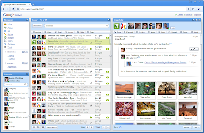
Here's how it works: In Google Wave you create a wave and add people to it. Everyone on your wave can use richly formatted text, photos, gadgets, and even feeds from other sources on the web. They can insert a reply or edit the wave directly. It's concurrent rich-text editing, where you see on your screen nearly instantly what your fellow collaborators are typing in your wave. That means Google Wave is just as well suited for quick messages as for persistent content — it allows for both collaboration and communication. You can also use "playback" to rewind the wave and see how it evolved.

As with AndroidGoogle Chrome, and many other Google efforts, we plan to make the code open source as a way to encourage the developer community to get involved. Google Wave is very open and extensible, and we're inviting developers to add all kinds of cool stuff before our public launch. Google Wave has three layers: the product, the platform, and the protocol:
  • The Google Wave product (available as a developer preview) is the web application people will use to access and edit waves. It's an HTML 5 app, built on Google Web Toolkit. It includes a rich text editor and other functions like desktop drag-and-drop (which, for example, lets you drag a set of photos right into a wave). 
  • Google Wave can also be considered a platform with a rich set of open APIs that allow developers to embed waves in other web services, and to build new extensions that work inside waves.
  • The Google Wave protocol is the underlying format for storing and the means of sharing waves, and includes the "live" concurrency control, which allows edits to be reflected instantly across users and services. The protocol is designed for open federation, such that anyone's Wave services can interoperate with each other and with the Google Wave service. To encourage adoption of the protocol, we intend to open source the code behind Google Wave. 
So, this leaves one big question we need your help answering: What else can we do with this?

If you're a developer and you'd like to roll up your sleeves and start working on Google Wave with us, you can read more on the Google Wave Developer blog about the Google Wave APIs, and check out the Google Code blog to learn more about the Google Wave Federation Protocol

If you'd like to be notified when we launch Google Wave as a public product, you can sign up at http://wave.google.com/. We don't have a specific timeframe for public release, but we're planning to continue working on Google Wave for a number of months more as a developer preview. We're excited to see what feedback we get from our early tinkerers, and we'll undoubtedly make lots of changes to the Google Wave product, platform, and protocol as we go.

We look forward to seeing what you come up with!

Update @ 7:07PM: The video of the Google Wave keynote presentation is now available:

Thursday, May 28, 2009


Google search basics: Basic search help

Search is simple: just type whatever comes to mind in the search box, hit Enter or click on the Google Search button, and Google will search the web for pages that are relevant to your query.

Most of the time you'll find exactly what you were looking for with just a basic query. However the following tips can help you refine your technique to make the most of your searches. Throughout the article, we'll use square brackets [ ] to signal queries, so black and white ] is one query, while black ] and white ] are two.

Some basic facts

  • Every word matters. Generally, all the words you put in the query will be used. There are some exceptions.
  • Search is always case insensitive. Searching for new york times ] is the same as searching for New York Times ].
  • With some exceptions, punctuation is ignored (that is, you can't search for @#$%^&*()=+[]\ and other special characters).

Guidelines for better search

  • Keep it simple. If you're looking for a particular company, just enter its name, or as much of its name as you can recall. If you're looking for a particular concept, place, or product, start with its name. If you're looking for a pizza restaurant, just enter pizza and the name of your town or your zip code. Most queries do not require advanced operators or unusual syntax. Simple is good.
  • Think how the page you are looking for will be written. A search engine is not a human, it is a program that matches the words you give to pages on the web. Use the words that are most likely to appear on the page. For example, instead of sayingmy head hurts ], say headache ], because that's the term a medical page will use. The queryin what country are bats considered an omen of good luck? ] is very clear to a person, but the document that gives the answer may not have those words. Instead, use the query bats are considered good luck in ] or even justbats good luck ], because that is probably what the right page will say.
  • Describe what you need with as few terms as possible. The goal of each word in a query is to focus it further. Since all words are used, each additional word limits the results. If you limit too much, you will miss a lot of useful information. The main advantage to starting with fewer keywords is that, if you don't get what you need, the results will likely give you a good indication of what additional words are needed to refine your results on the next search. For example, weather cancun ] is a simple way to find the weather and it is likely to give better results than the longerweather report for cancun mexico ].
  • Choose descriptive words. The more unique the word is the more likely you are to get relevant results. Words that are not very descriptive, like 'document,' 'website,' 'company,' or 'info,' are usually not needed. Keep in mind, however, that even if the word has the correct meaning but it is not the one most people use, it may not match the pages you need. For example, celebrity ringtones ] is more descriptive and specific thancelebrity sounds ].

How to read search results

Google's goal is to provide you with results that are clear and easy to read. The diagram below points out four features that are important to understanding the search results page:

search results

  1. The title: The first line of any search result is the title of the webpage.
  2. The snippet: A description of or an excerpt from the webpage.
  3. The URL: The webpage's address.
  4. Cached link: A link to an earlier version of this page. Click here if the page you wanted isn't available.

All these features are important in determining whether the page is what you need. The title is what the author of the page designated as the best short description of the page.

The snippet is Google's algorithmic attempt to extract just the part of the page most relevant to your query. The URL tells you about the site in general.

For more information see the More search help page.